
By Puja Bhattacharjee
Falls Creek Baptist Conference Center, the oldest church camp in Oklahoma, hosts more than 50,000 kids and teens who come for summer camp each year. Falls Creek originates from the Washita River in Murray County and flows directly into the campgrounds named for it.
But flash floods now menace the camp and the facility all but closed after a 2015 flood left a few hundred campers stranded for more than 36 hours. So far, scientists do not know what caused the flooding.
With warming global temperatures, though, flash floods are becoming an increasing threat across many area of the US. So on a balmy April morning this spring, three researchers from the National Severe Storms Laboratory (NSSL) in Norman, Okla., drive more than 60 miles to the camp in a black pickup truck crammed with instruments in big boxes.
Jonathan Gourley drives the truck. In the backseat are Pierre-Alain Ayral and Jorge Duarte. Gourley, a research hydrologist at NSSL is the only American in the team. Ayral is a geographer and hydrologist from Mines of Ales, a technology and engineering university in France. He’s visiting on an exchange program between NSSL and the university. Duarte, the youngest member of the team, came originally from Colombia and works as a system engineer with NSSL. They drive past acres of open fields along a highway dotted with billboards under clear blue skies. As they near the camp, they pass the Arbuckle Mountains and enter a narrow road with thick foliage on either side.
“There is no evidence that flooding has increased or decreased in the creek,” Gourley says.
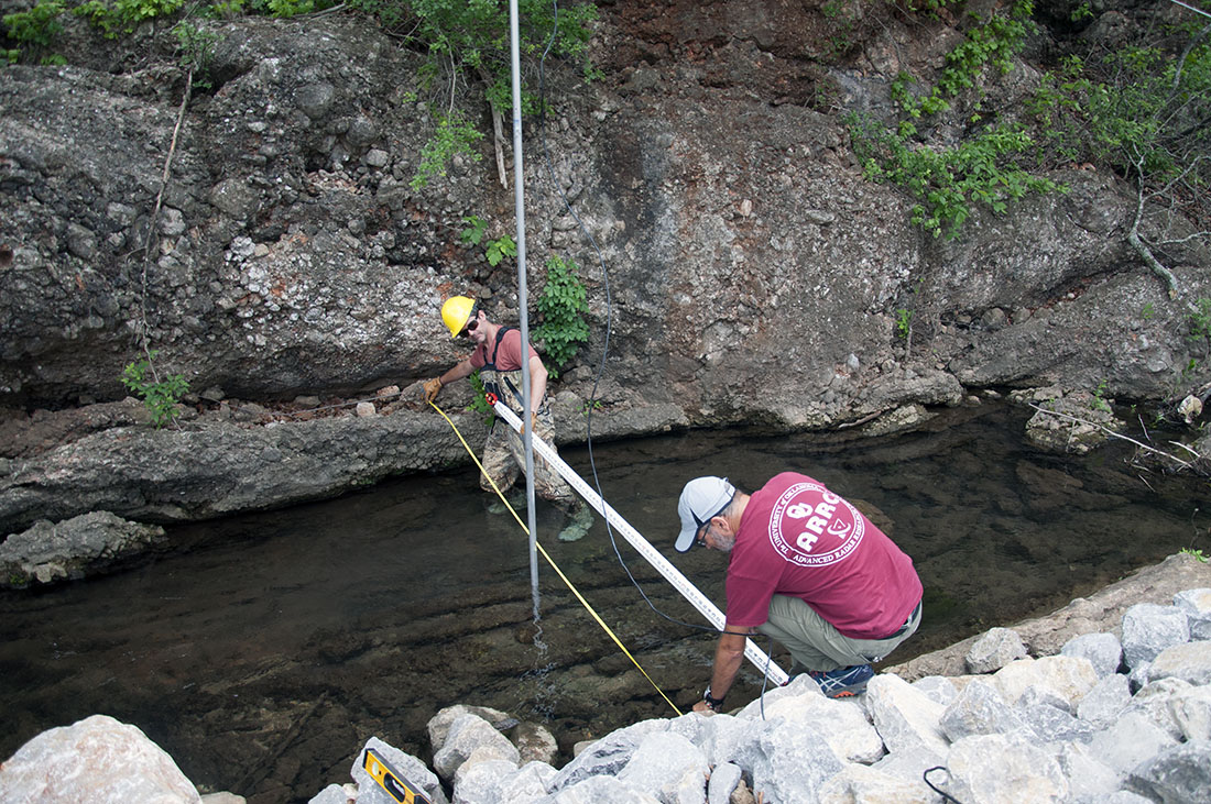
This is one of the several trips the team has made to test a new remote sensing instrument for lash floods. After parking the car near the creek, Gourley swiftly changes into a pair of waders, waterproof gloves and a hard hat while the other two navigate a stretch of carelessly thrown rocks to reach an inconspicuous box attached to a building near the creek. These rocks known as rip rap were dumped on the banks of the creek to retain the soil and slow down the water. Duarte takes out his laptop, connects it to wires in the box and sits down on a rock.
In front of him, above the stream, a “stream flow” radar device for detecting the velocity and height of water in the creek hangs suspended, tethered to two trees and to the building just above the box. The box contains the battery, data logger and solar charging system for the radar. Duarte provides instructions to the data logger, tells the radar what to do and stores the data received. The data logger communicates with the stream flow radar and gets some readings and logs the data and sends them via cellular network to Duarte. “That allows us to keep track of stream flow data,” says Duarte.
If a flash flood moves their way, the solar-powered radar unit should alert them. It can operate up to two days without sunlight. “Maybe on cloudy days it will still get charged,” he says.
Gourley maneuvers the rip rap with two eight-foot poles on his shoulders. Duarte and Ayral help him join the poles and attach the Light Detection and Ranging (LiDAR) instrument that will be used for remote sensing at the top of the pole. The instrument joins two rectangular boxes, one a little taller than the other. The shorter box has a funnel at the base and another much smaller box with a rectangular opening on top of it. The LiDAR shoots red laser pointers. One of them points straight down to measure the distance from that radar to the water surface through the funnel. If the water level starts to rise that distance becomes reduced. The second radar in the rectangular opening is offset at an angle pointing upstream, measuring the velocity of the surface water.
“Where I am standing, I can see a lot of ripples and that is what the radar is also detecting. To get the depth, we need to know what the bottom looks like. That’s where we need the LiDAR. LiDAR gives distance between the bottom and water surface,” says Gourley. If the creek gets deeper with flooding, the LiDAR detects it.
Discharge of the stream in cubic meters per second or gallons per second can be calculated from the measurements from the radar and LiDAR. “That way we can analyze the trends of the stream. If the stream is growing rapidly, we can issue alerts for people at Falls Creek,” says Duarte.
A warning is critical given the seemingly arbitrary strikes of the previous flash flood.
“On a previous excursion here, we gathered some data on the cross section. We measured the cross section of the stream and we worked out a graph how the profile of the stream looks. This I will program into the stream flow radar,” he adds. Today they will try and get more accurate data with the hope of improving measurements of the profile.
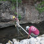


Gourley wades into the middle of the stream and holds the poles erect right next to the radar. Duarte leaps to the other side of the stream on to a rising rocky terrain and Gourley throws him cables attached to the poles. He ties them to the branches of trees growing out of the hillock. He then jumps up and down, stabilizing the LiDAR pole to make sure it’s not too tight and can stand without support from Gourley. While he’s at it, he attracts a huge spider right on him. He is eager to get to the other side, safe from the creepy crawlers.
Gourley kicks the clear water to make it turbid and ensures the LIDAR is working properly. A lot more measurements under different conditions are required. Some rivers are never pristine. Scientists trying to determine the conditions where they are certain the LIDAR is working accurately.
“My legs are a little cool and one side is wet because my waders leak a little bit. Other than that, it’s quite nice,” says Gourley. Once everything is stabilized, he comes back to the rocky bank.
Duarte provides instructions to the data logger, tells the radar what to do and stores the data received. The LIDAR at present is controlled by a computer. Once the scientists can prove that measurements gathered from the radar and LIDAR are high quality, the LIDAR will be attached to the radar. The data logger will also tell the LIDAR what to do. It is still in testing with and not ready to be integrated yet.
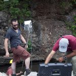
To validate the measurements taken by the LIDAR, the team takes another set of measurements in the traditional way – simply measuring the depth of the creek. Ayral assembles a device known as the Total Station. It is a complex electromagnetic distance measuring instrument consisting of lenses, focus rings, a display screen and prism mounted on a tripod. The Total Station allows them to perform manual topographical/bathymetrical (riverbed and water level) surveys, and gather data to contrast with the measurements performed by the LiDAR.
It’s been four hours since they arrived.
Duarte dumps saltwater at the head of the stream. A little distance away, Ayral is ready with the conductimeter in the stream to measure the conductivity of the water, which is related to the amount of salt in the flow. The conductimeter will take measurements which will be analyzed back in the lab on how quickly conductivity changes with the flow of water. This will then be compared with the remote measurements with radar and LIDAR combined to tell if they are functioning correctly.
the Streamflow Radar can also be programmed to estimate discharge, by providing it with a cross section configuration, which is derived from the LiDAR measurements.
The team conducts manual secondary measurements to every type of measurement of the remote sensors perform, to establish their precision, accuracy and viability in application scenarios.
The LiDAR is using a lot of components which can be bought off the shelf. “We bought the LiDAR and integrated it into a mechanism that simply enables scanning. We will tell the instrument where to point and take measurements and then move to a new position and take measurements and so on. In the future, we will be able to do it from our desktops or cell phone,” says Gourley. Once it has been installed there is not much to be done other than basic maintenance such as checking the battery and making sure animals haven’t gotten into the cords. But Falls Creek is the only place they are testing the equipment so far.
Remote sensing is safer, cheaper and requires no contact with water. The complete is mounted above a water body. It is tricky to figure out where to mount the setup. Radar works well when it can sense the ripples in the water. In still water, it is difficult to get radar measurements.
“Everything you see here is a prototype. Once we integrate the systems, we can provide measurements anywhere,” Gourley says. “We are testing out a remote sensing method. If we can prove that the technology works then we can put these kinds of instruments high above rivers and obtain the information we need without having to get into the water and do these surveys in a manual basis. Automated surveys are safer and cheaper.”
Since April, the team has been down to Falls Creek several times to perform more measurements, maintenance, and gather more data. On the night of May 19th, the streamflow radar captured and recorded data on water level, velocity and discharge on a flash flood event at Falls Creek. This enabled the researchers to comply with one of this project’s main goals.
“It is pretty rare that we captured an event of the magnitude that we did,” Gourley says.
Two new researchers have joined the project. They are working to estimate the limitations of our LiDAR applications and quantify the uncertainties of the methodologies related to the remote sensing equipment and techniques.
