

By Kathleen Ferraro
Keep your eyes on the skies, especially for space archaeology in the Middle East.
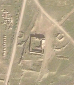
Archaeologists have long used satellite images to detect and map archaeological sites on the ground. Now, they are turning this bird’s eye view to damaged sites in the Middle East; policing destructive forces from the skies.
“The use of satellite imagery that’s become very widespread in the last couple of years is to monitor cultural heritage sites that are in conflict zones,” said Emily Hammer, an archaeologist at the University of Chicago.
Researchers now scrutinize satellite images outside of strictly archaeological contexts, using the pictures to observe sites that have been or are at risk of being destroyed or looted–particularly by the Islamic State. To preserve cultural heritage and monitor illegal artifact trading activities at these ancient sites, archaeologists survey destruction from above, said Hammer.
In the field of space archaeology, researchers frequently use satellite images to scout out potential sites for research, evaluate landscapes and supplement necessary on-the-ground fieldwork.
“Part of it is knowing what to look for, really. You know how it would look on the ground, from experience, so you kind of can visualize what it might look like from space,” said Mark Altaweel, an archaeologist at University College London’s Institute of Archaeology. “It’s a combination of just knowledge as well as some science and principles behind it.”
Archaeologists turn a trained eye to aerial images to identify noteworthy environmental and man-made features in the landscape. From there, researchers evaluate the site on the ground to determine if it’s worthy of excavation, Hammer said.
The aerial sniffing, touted for its technological prowess, is an evolving art that has in fact been around for nearly a century.
“The U.S. military and also the Royal Air Force and many other Western military organizations were taking photographs from planes,” Hammer said. “But those images, going back to the ’40s, sometimes even to the ’20s or the 1910s, those have been used in archaeology for a really long time.”
Going back to the era of taking photographs in hot-air balloons, archaeologists have a long history of examining sites from the sky. Researchers use satellite images taken from Google Maps and commercial satellite companies.

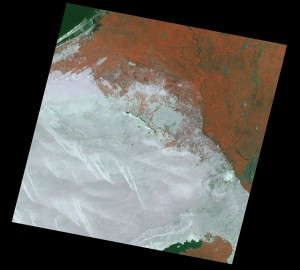


The satellite images don’t come cheap. Altaweel was quick to emphasize the costliness of these images. The data, though helpful, is not necessarily accessible without the proper resources. Some images come at $8 a strip, while other high-resolution satellite images can be up to $500, he said.
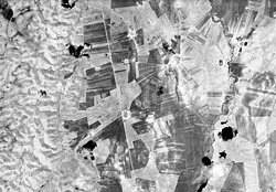
And scientists still rely on old photographs, digitizing them for online research.
In terms of monitoring landscapes of the Middle East over time, declassified U.S. military photographs, particularly those from the Cold War, are especially valuable, according to Hammer.
“They preserve what the landscape of the Middle East looked like before the advent of modern agriculture,” she said. “Modern agriculture has been extremely destructive to archaeological sites and also to traces of what the ancient environment was like. Those old photographs are really valuable because they show what everything looks like before those changes occurred.”
But these images of Middle Eastern sites aren’t strictly used for archaeologists searching for the best place to dig. Following the Arab Spring in 2010, many ancient spots in the Middle East have been destroyed or looted. Archaeologists recognized the potential utility of satellite imaging techniques, and stepped in to fight for preservation.
The Islamic State routinely demolishes archaeological areas: damaging them for media attention and pillaging the sites for profitable artifacts.
Hammer, director of University of Chicago’s Center for Ancient Middle Eastern Landscapes (CAMEL) lab, noted satellite imagery’s ability to track the Islamic State’s destructive wake and illegal activities. In particular, there is currently a debate among international organizations about the Islamic State’s antiquity dealings; speculation as to how much revenue artifacts generate to sustain the terrorist organization, she said.
“It does help groups, like various task forces in the UN, that are trying to track how the Islamic State is making money,” she said. “Obviously, the Islamic State is sustaining itself largely on oil sales, but they are also looting and selling antiquities at a really frightening scale.”
And archaeologists aren’t just monitoring these site–they’re also brainstorming what to do next.
Nadine Moeller, an archaeologist and Egyptologist at the University of Chicago, noted that information obtained from satellite imaging can do more than assess damage to archaeological sites. It can help build bridges to local authorities and give them insight into the illegal antiquities trade and the need to preserve local cultural heritage.
“Ideally you want to work with the local authorities and the local people. It’s a lot about creating awareness, education, supporting local efforts, because you can’t just waltz in there and come up with standards,” she said. “You need to actually find the reasons-what are they financing, what are they doing with these objects, to whom are these objects being sold?”
Moeller noted the continued importance of archaeological monitoring in the Middle East.
“I think the whole problem, with especially the looting, that all that came to light and became increasingly problematic after the Arab Spring,” she said. “I think that’s where this whole technology will be more used than ever. That’s really one of the key future efforts.”
