By Puja Bhattacharjee
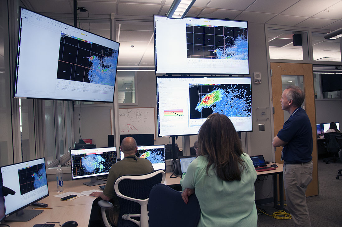
People start trickling into the National Severe Storms Laboratory holding coffee cups and laptops. By 8 a.m., eight people fill a room for the Spring Experiment. The laboratory in Norman, Okla., is open all year. But now it’s tornado season.
Researchers, forecasters, software developers, IT personnel and scientists from different parts of the country have come together for the annual experimental program held during the spring severe weather season to test and evaluate new techniques and tools for hazardous weather forecasting.
One of the goals this year is to continue testing software that could possibly eradicate false alarms, issue more accurate and detailed warnings for tornadoes and other severe weather. “The false alarm ratio of a one-hour forecast of a tornado should be smaller in the future if the research pans out – meaning fewer one-hour forecasts of tornadoes will be wrong,” says Greg Stumpf, who heads this program.
This is the third week of the project. Each week, new forecasters join it with the permanent researchers such as Greg Stumpf, a meteorologist working for Cooperative Institute for Mesoscale Meteorology Studies (CIMMS) at the University of Oklahoma. He and colleagues designed the experiment to increase the warning time people can get when a severe storm comes their way. Minutes matter. It’ life or death.
Stumpf, gracefully middle-aged, sports a slight goatee. He is, metaphorically speaking, the captain of the ship but runs it with upbeat camaraderie and respect. He is familiar with the role of all the participants and that enables him to guide it in the right direction.
A few minutes past 8, Stumpf begins the session with a presentation explaining the role of Hazardous Weather Testbed, providing the conceptual computer framework in the room for the testing project. The first day is spent getting the participants acquainted with the software they test in the days that follow. The test means staying glued to their computer screens interspersed by short interactions for clarifications. Their screens glow green, yellow, red and blue with heat maps over various states and counties of the country, each map representing a variable such as wind speed, pressure, moisture and new ways to interpret what different combinations mean – especially the crisis combinations that cause severe storms. You wouldn’t know that from the silence in the room, punctuated with taps on the keyboard and the sliding mouse on the table.
The National Severe Storms Laboratory is on the first floor of the National Weather Service in Norman. The building also houses other facilities of the National Oceanic and Atmospheric Administration (NOAA). These include the National Weather Service’s Storm Prediction Center and the Norman Weather Forecast Office plus Oklahoma University’s meteorology facilities. Inside the NSSL premises, a pair of wood framed glass doors leads to the large testbed room. Tables line the walls and chairs are scattered across the room. Numerous computer screens occupy the tables. Some hang from the walls. The glass walls on either side of the room look into the Norman Forecast Office on the left and Storm Prediction Center on the right.
So, what is this project?
Not too long ago, each county had a local weather forecasting office. Now the forecasting is prepared as a grid appearing on a computer screen. The grid that is used today for NWS forecasts is 2.5 km. How many grid points fall within a county? That all depends on the size of the county.
Computer screens updates every minute. At present, if forecasters believe there is a good potential for a severe storm to produce a tornado, they issue a warning. The warning is issued only for a swathe of land encapsulated within a box of grids where the meteorologists feel the storm has a good chance of hitting. The entire population within the box is warned of severe weather. However, not everyone inside “the box” necessarily experiences severe weather and not at the same time. This project team is trying to be more specific with issuing warnings.
Instead of issuing warnings for one box, meteorologists are creating a grid from which different boxes or areas can be drawn. There can be one box for people who need to be warned earlier and another box for people who don’t need to be warned immediately. Right now, tornado warnings are issued with a lead time of 30-60 minutes. The goal is to increase that, possibly to as such as two hours. Places such as hospitals and schools need more time to get everyone to safety. NSSL is working to create a system that will give a lower probability, longer lead time warnings. Even if the chance of being hit by a tornado is less, it’s still important to take cover because the danger of them being hit by a tornado is much greater than for people farther away. For an outdoor excursion such as people camping at a site after hiking there, the campers have to hike back to their cars and then drive to a safe place to take shelter that may be a half-hour away. Their response to the event may take an hour or more of warning time.
This software allows forecasters to deliver the spectrum of information to all those users and allows emergency managers to set their own threat tolerance level, Stumpf says.
Each box is made using a software that scans radar data, capturing the storm and then projecting where it is going to go. “This project is looking at a new way of communicating information used in probability grids,” says Stumpf. The software creates the grids from which more than just regular warning information can be obtained such as sub-warnings, which have greater lead time, i.e. it will be a while before severe weather hits. The sub-warnings may extend a lot farther away from the storm for people that need more time to get to the shelter, people who may be at hospitals, schools and outdoor locations. Many schools don’t have shelters of their own, a controversy in Oklahoma.
At present, short-term severe weather forecasts are less certain the farther we go into the future. For the longer lead time folks, there is a lower probability of being hit but it makes sense for them to take cover even with that lower chance. Tornadoes are just too dangerous.
On the teams gathered to test the new software, each person has a defined role in the setup.
Tracy Hansen is a software engineer and technical lead at NOAA’s Global Systems Division based in Boulder, Col. She is the lead architect of the team of four people that developed the software – Hazard Services-Probabilistic Hazard Information. The software development team works remotely from Colorado, Ohio, and Oklahoma.
The first PHI prototype software was developed and tested from 2006-2008. The second PHI prototype began development in 2013 and is still under development. Development of the latest version of the software, designed for the official NWS work stations, began in the summer of 2015 and continues.
The crucial participants in the experiment are the forecasters. They will be testing the software to see if it is working properly and what features might need to be added to it. During the third week of the project, Matt Friedlein and John Stoppkotte join the testing team. Friedlein is a lead forecaster at NWS in Chicago. His job is to issue a weekly forecasts for the Chicago metro and surrounding areas -public forecasts, detailed forecasts for aviation, including for O’Hare and Midway airports and the forecast for Lake Michigan. Stoppkotte is the science and operations officer (SOO) at NWS in North Platte, Neb. Whenever there is a new technology or forecasting techniques or a breakthrough in the science of meteorology, it is his job to integrate that into the general forecasting idea and to the forecast staff.
The team gathers on a Monday and starts testing the software the next day. Before the testing can begin, Alyssa Bates sets up a hypothetical scenario, using data from real severe weather cases and tornadoes, as if it was happening in real time. The experiment is timed and different pieces of data are brought in at certain times to simulate a real severe weather situation. Bates is here with her colleague Jim Ladue. They are from the Warning Decision Training Division of NWS and have been part of the project from the very beginning. They will help design the training for the forecasters once this new software becomes available across the nation. They are there to get an idea how to develop the training once NOAA makes the system operational. If they waited till the software becomes operational to start developing the training, they will be too late – forecasters will want to use it right away.
Friedlein and Stoppkotte sit side-by-side, two screens facing each of them. They are silent throughout as each keenly observes the shifting heat maps on their screen. A desktop application records all the decisions taken by the forecasters on the computer to a file. Two video cameras mounted on sleek tripods record the actions of the forecasters as they work. They will be given to Joseph James to analyze the forecasters’ body language and comments. James is a Ph.D. student at the University of Akron and a human factor engineer. His job is to tell the software team the best way to design the software so that the forecasters can make their decisions quickly and efficiently. For example, in old American cars, the driver had to tap a button on the floor with their foot to turn the high beam lights on. Now that we think about it, it didn’t make sense. Why not just put the control up next to the steering wheel to click it on and off? That change in design was brought by human factors study. Social sciences play a very important role in communicating scientific information to the public.
What is social science?
“Most people don’t seek shelter when they hear a tornado warning. They go outside to look. It’s called seeking confirmation. It is general human behavior,” Stumpf says. But meteorologist didn’t know that. Before social scientists informed them of this, meteorologists were baffled and frustrated when people didn’t take shelter right away. So now, meteorologists approach severe weather warnings differently. Instead of telling people they need to seek shelter immediately, they tell them to be in the shelter by a certain time.
“If you tell them by when they need to be in their shelter, they can determine themselves how long they can stay outside and watch,” Stumpf notes. Social scientists changed the way meteorologists communicated the information.
Social scientists help meteorologists determine how to convert the data they gathered from the grid into a message that people will understand. “We are not just testing a software but a whole new concept. It is an entirely different way of communicating hazardous information,” Stumpf says.
After each experiment, the forecasters filled out a human factors survey assessing how easy it is for forecasters to apply the software to a variety of weather scenarios. They had to push the software to its limits to see what kind of changes needed to be made. The goal was to convey as much information as quickly as possible. Stumpf selected simple events for testing at the start of the week but they became more complex as the week wore on. The idea was to test their ability to handle more complex events as they got familiar with the system.
By the end of the week, each participant has his own takeaway. As the software developer, the feedback mattered the most to Hansen.
“We are going to take information from the grids they produced to see if they operate it with more efficiency towards the end of the week, after they used it for several days. We still have to fix some bugs in the software and prioritize which new features go in,” Stumpf says..
“There are a few software things here and there as with any new software. Some glitches are not glitches at all but inexperience in using the software,” says Stoppkotte at the end of the week.
James says the new system is more advanced and has a lot of different aspects and tasks that the forecasters need to complete. “The work load is a concern. We do not want the forecasters to be fatigued or have trouble communicating the weather threats to users.”
“My goal is to take what I have learned here and the software and show them (staff) what’s coming, get them familiar with it and start to understand the concept now,” says Stoppkotte. “I am a veteran in this setup. I was here three years ago and worked with the software in its then form. I am very optimistic to see how it has changed and evolved over time.”
“What we learned as forecasters is a new way of approaching warnings,” said Friedlein. “I will be going back to my office in Chicago with a better vision of where we are going in weather service in terms of severe warnings. Keeping that in mind with our nowadays warning paradigms, we will be able to apply some information in the meantime until this is possibly released across the agency in a few years,” he adds.
The team will repeat this process next spring with a newer, improved version of the software. Meanwhile, they will collect more feedback and make some more improvements. Once they feel ready, the software will be offered nationally and run in the forecast offices for actual operations.
“There is still much more research to be done before we feel confident that the software will be ready, perhaps at least 3-5 more years,” says Stumpf.
That could take place in time for the 2022 tornado season.


